How do we measure plate movement?
-Earthquakes, volcanoes, and mountain ranges are a way of showing plate movement.
-The Theory of Plate Tectonics shows that convection currents inside the Earth can affect the crust differently in different places.
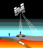
-Scientists use satellite and laser technology to messure the exact movements of plates to the last cenimeter.
-Laser pulses are shot to the ground to a sattelite to determine an exact location on the ground.
-New data shows that the crust is moving 1-12 cm each year.
-Here are some examples:
-The Atlantic Ocean is expanding.
-North America and Europe are being taken about 3 cm further from each other each year.
-Hawaii is getting closer to Japan and moving 8.3 cenimetres each year
-The Theory of Plate Tectonics shows that convection currents inside the Earth can affect the crust differently in different places.
-Scientists use satellite and laser technology to messure the exact movements of plates to the last cenimeter.
-Laser pulses are shot to the ground to a sattelite to determine an exact location on the ground.
-New data shows that the crust is moving 1-12 cm each year.
-Here are some examples:
-The Atlantic Ocean is expanding.
-North America and Europe are being taken about 3 cm further from each other each year.
-Hawaii is getting closer to Japan and moving 8.3 cenimetres each year
